Infrastructure

You want to know what has to be done so APPs and web applications work? Who is responsible for the interdisciplinary cooperation of different subprojects and the public communication of their work? How the data is afterwards evaluated and visualized? We put together a short introduction about out three infrastructure projects. Learn more about coordination, IT infrastructure and the ClimateEventPortal.

Coordination and Communication

Subproject 1 focuses on BAYSICS' general administrative tasks, including the coordination of nine scientific subprojects encompassed within the network. Reinforcing the project’s inter- and trans-disciplinary approach with regards to content, methodical and practical implementation is of central importance here.

IT-Infrastructure

Citizens create science: recent social and technological developments have paved the way to include citizens in research in new ways. The digitalization of our society enables and demands new levels of civil participation in scientific projects. The internet and new mobile communication devices revolutionize citizen participation and education worldwide.

ClimateEventPortal

This subproject is dedicated to assessing the value of climate related event data. By definition, an event encompasses a spatiotemporally significant change. It is typically characterized by its duration (when), geographic location (where), the changing pattern (how), involved subjects (who) and involved objects (what).

Coordination and Communication

Subproject 1 focuses on BAYSICS' general administrative tasks, including the coordination of nine scientific subprojects encompassed within the network. Reinforcing the project’s inter- and trans-disciplinary approach with regards to content, methodical and practical implementation is of central importance here.
Specific coordination measures include organizing regular joint meetings, developing and implementing project-specific ethics guidelines, as well as the drafting of a collaborative manuscript which outlines a detailed communication, publication and dissemination strategy for results.

Subproject 1 is additionally involved in creating a style-guide to be used by all project partners for their public relations and marketing work. Using collaborative software, files and data are collected and shared amongst BAYSICS partners to facilitate scientific cooperation and promote joint publishing.
Yet another focus of the work is to establish, expand and maintain a broad communication and press network. Via customized information bodies, internal networks and mass media sites, contributions tailored to each target group will be published on a regular basis to help promote a sustainable interest in BAYSICS citizen-science and research.

The design and development of mobile applications ('Apps') for sub-projects 4-7 is furthermore supported by spearheading the target-group analysis, the composition of a modular IT system and the design & development of a common user-friendly interface.
BAYSICS Logo Schrift groß
BAYSICS Logo Simple
BAYSICS Logo Schrift

Project Management

Profilbild von Frau Prof. Dr. Menzel

Prof. Dr. Annette Menzel
Technical University Munich
Professorship for Ecoclimatology
E-Mail: annette.menzel@tum.de
Phone: +498161 714740
Hans Carl-von-Carlowitz-Platz, 85354 Freising

IT-Infrastructure

Citizens create science: recent social and technological developments have paved the way to include citizens in research in new ways. The digitalization of our society enables and demands new levels of civil participation in scientific projects. The internet and new mobile communication devices revolutionize citizen participation and education worldwide.
Combined with simple and cheap sensors for data collection, they form a key requirement for citizen science projects. Nonetheless, a flexible IT infrastructure that offers more than simple tools to communicate about a project's content is lacking, particularly in the context of environmental sciences.

To enable more agile developments, the Leibniz Supercomputing Centre aims to create an infrastructure tailored to the BAYSICS application. A multitude of modular tools will support scientists and scientific laymen to answer their research questions. Tools will comprise a mixture of methods, from online learning and interview platforms to social media. The open structure design will further enable integrating projects and tools from beyond the BAYSICS network.

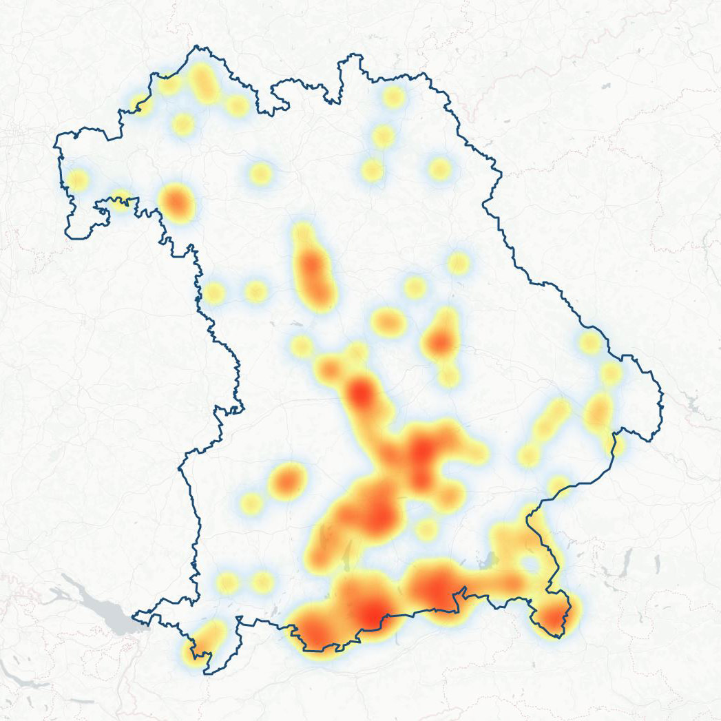
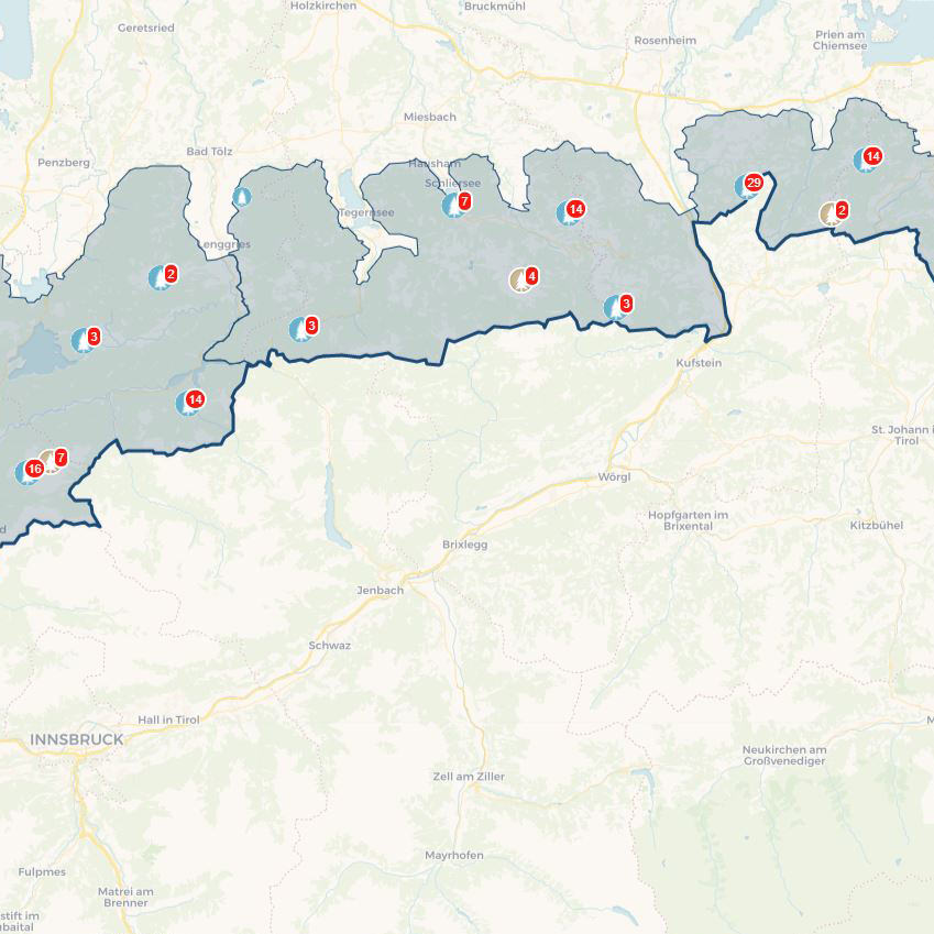
Finally, visualization plays a key role in this project. On the one hand it is meant to foster scientific analyses, and on the other hand it should illustrate data in a way that make results understandable for policy makers and the public. For scientific purposes, visualizations need to present measured or simulated data in a way that enable scientists to draw new knowledge from them. Within this project the general public is a target audience, however, meaning that intuitive and instructive presentation will be of central importance.

Project Management

Porträt von Prof. Kranzlmüller zuständiger für IT-Infrastruktur

Prof. Dr. Dieter Kranzlmüller
Leibniz Supercomputing Centre
of the Bavarian Academy of Sciences and Humanities
E-Mail: Kranzlmueller@ifi.lmu.de
Phone: +49 89 35831 8700
Boltzmannstr.1, 85748 Garching

ClimateEventPortal

This subproject is dedicated to assessing the value of climate related event data.

By definition, an event encompasses a spatiotemporally significant change. It is typically characterized by its duration (when), geographic location (where), the changing pattern (how), involved subjects (who) and involved objects (what).
From a public standpoint, events like forest fires, floods or landslides are more relatable than sheer numbers and facts. Climate and environmental scientists thus use events as meaningful information units for the visualization, analysis and discovery of complex spatiotemporal distribution patterns, correlations, causalities and more.

By use of OpenStreetMap (OSM) and Bavaria's official Digital Landscape Model, an open “Climate Event Portal” will be developed with two main functions:
  1. the interactive and automatic extraction of climate-related event data from social media and digital archives
  2. the interactive and automatic recognition of complex relationships within accessible event data.
The objective is to hereby demonstrate synergetic effects between science, education and public engagement and to establish a foundation for knowledge-based citizen science initiatives on climate protection.

Project Management

Porträt von Prof. Meng zuständig für das Teilprojekt KlimaEventPortal

Prof. Dr. -Ing. Liqiu Meng
Technical University Munich
Chair of Cartography
E-Mail: liqiu.meng@tum.de
Phone: +49 89 28922826
Arcisstraße 21, 80333 München

Heatmap Karte vom BAYSICS Portal
Karte mit Gebirgsstöcken vom BAYSICS Portal

We are grateful for all our cooperation partners. Check them out and find out about their promotions.

BAYSICS is funded by: